Marker 123
It has been said—by a scholar who studies such things—that the function of a picture postcard is to make the unnoticed noticed. If nothing else, a postcard is a kind of mailable landmark—with graffiti scrawled on back. I have a growing collection of old postcards from the Catskill Mountains. Most of them come from bins in antique stores or off of eBay. I’m not very discriminating in my taste. Nor am I willing to pay more than a buck or two for any of them.
Recently I came across a postcard of a stretch of highway that looked familiar. Sure enough, the back of the card is labeled: “New York State Thruway Looking North From Marker 123, 9 Miles North of Catskill Exchange.” It was postmarked in 1957 and addressed to a couple residing in Québec. The message is written in French, but that’s not why I can’t make out the words—the handwriting is terrible. It probably says something along the lines of: “Having a great time! Wish you were here!” And that’s what piqued my curiosity: What could possibly be of touristic interest at Marker 123 along the Thruway? What makes this spot worthy of a picture postcard? After all, it’s no Kaaterskill Falls or Pratt Rock. What is going on here? So I got into the car and drove down to Coxsackie to find out for myself.
19th Century Toll House, Climax NY
First problem I ran into: I forgot my wallet. And the E-ZPass was in the other car. I would have to stick to the back roads and attempt to reach Marker 123 by foot, proceeding cross-lots through some sketchy terrain. I did have my GPS, which directed me from Windham down to Greenville and then toward Coxsackie via Route 81. Just past Climax is a Thruway overpass that lies but a short distance south of my destination. Here is where I ran into my second problem: a daunting barrier of fencing between me and the pleasant swards of the Thruway. No way to get over or around that. To make matters worse, there was nowhere to park without arousing suspicion. So I continued past this place and turned off on a quiet side road that led in the right direction. Very quickly this ended in my third and final problem: a cul-du-sac guarded by a couple of hungry-looking watchdogs. I know a ne plus ultra when I see one. I turned around and resumed the search along the unfrequented roads abutting the superhighway. Alas, I had no luck. A feasible route to Marker 123 never presented itself. But I did gain a better understanding of the term “limited access.”
View of Roberts Hill and High Rocks from Parking Lot at Coxsackie Antiques Center
I returned home and did what all thwarted trespassers do: I fired up Google Street View. With the postcard image to guide me, I fixed my gaze on the monitor and rapidly clicked my way north on the southbound lane of the Thruway. I soon arrived at my destination. Or close enough, as Street View doesn’t let you get off the road—at least not yet. Even so, there on my screen was the same scene. Little about the spot has changed in the six decades between when the postcard picture was taken and when Google captured its image. Sure, the roadbed is showing its age, the trees on either side of the highway are taller, and the forest has encroached on the agreeable leas above the Thruway’s breakdown lanes—but there in the distance is the familiar profile of Roberts Hill, same as it ever was, save for the ample furrow of the 345 kilovolt transmission line coming down from New Scotland.
It occurred to me that I knew nothing about Roberts Hill except what can be seen from the Thruway. So I googled around and learned a little about its geology and history. The hill itself is part of a fifty mile long segment of sedimentary rock that geologists refer to as the Hudson Valley fold-thrust belt, “a narrow band of Silurian-Devonian strata” that parallels the west side of the Thruway from Kingston to Albany. So that’s what I’ve been looking at for all these years. Roberts Hill and the adjacent High Rocks are near the northern terminus of this formation.
Turning next to Clesson Bush’s book on the history of New Baltimore, I learned that, according to the 1850 census, the town had more than a hundred African American residents, most of them employed as farm laborers and domestic workers. A noteworthy few owned their own houses and lived close by to each other in “the south central part of town called Roberts Hill.” Mr. Bush remarks: “Why they happened to live near one another is a mystery worthy of further research.” Indeed. Roberts Hill is likely rich in many mysteries worthy of further research. Just like anyplace. Just like Marker 123, or your own place.
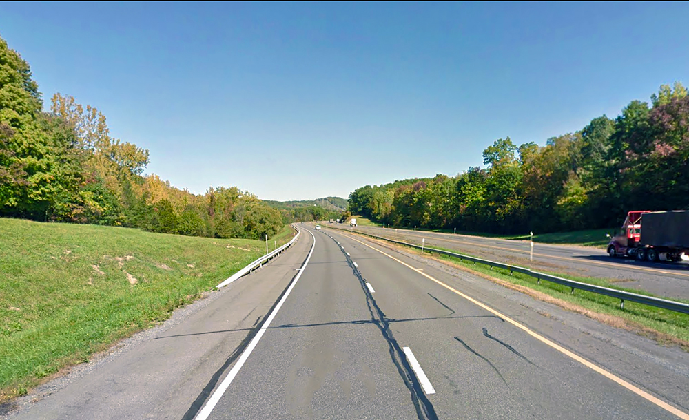
Mile Marker 123 As It Appears Today
©John P. O’Grady
(This piece originally appeared in the March 9, 2018 edition of The Mountain Eagle.)